River Environments
The Water Cycle
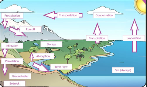
To understand river environments we must first be able to describe where water comes from and how it is transferred and stored. Geographers commonly refer to the water cycle or hydrological cycle to describe the transfers of water. Within the water cycle water enters the drainage basin. As part of the drainage basin water flows back to the sea via streams, rivers and groundwater flow.
Source: Met Office
Activity
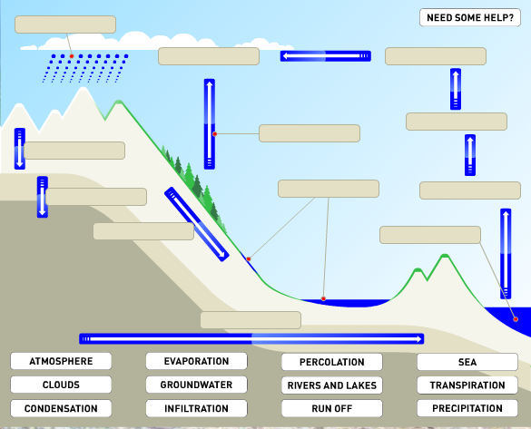
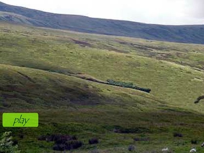
1. Test your knowledge by clicking on the picture below.
2. Write a transcript to go with the NASA animation
1. Test your knowledge by clicking on the picture below.
2. Write a transcript to go with the NASA animation
|
|
Glossary
You need to know a lot of vocabulary to describe the movement of water in the water cycle.
Evaporation - the turning of a liquid to a gas
Condensation - the release of water vapour into liquid
Precipitation - rain , snow, hail and fog
Run-off - the movement of water over the surface
Infiltration - when water moves vertically down through the soil
Percolation - when water moves vertically down through the rock
Transpiration - the turning of water into a gas from plants and other surfaces
Ground waterflow - the horizontal movement of water through rocks
Through flow - The horizontal movement of water through soils
Water Table - the zone of saturation in the ground.
Drainage Basins.
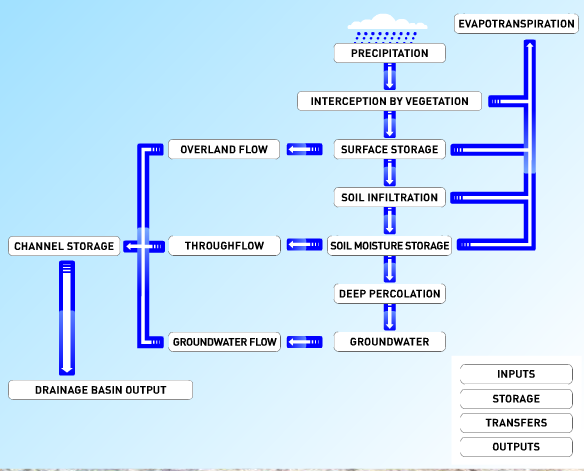
Drainage basins are different to the water cycle in two main ways. Firstly, the drainage basin is an open system with inputs and outputs whilst the water cycle is closed system with no inputs or outputs. The drainage basin is one prt of the water cycle.
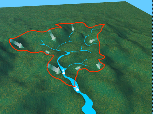
Drainage Basin - the area of land from which rainfall moves into a river
,
Drainage Basin - the area of land from which rainfall moves into a river
,
|
Funny Fact!
Did you know that the water you drink today was drunk by the dinosaurs of the Jurassic? Activity Study the flash resource to the left and identify the 1. Inputs 2. Storages 3. Transfers 4. Outputs |
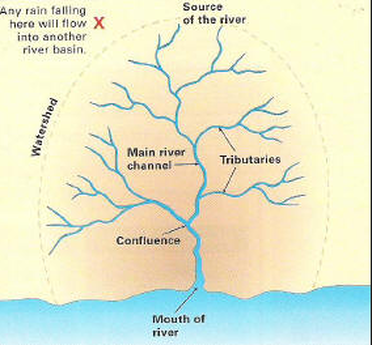
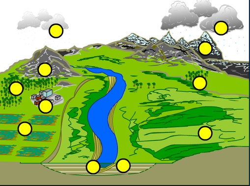
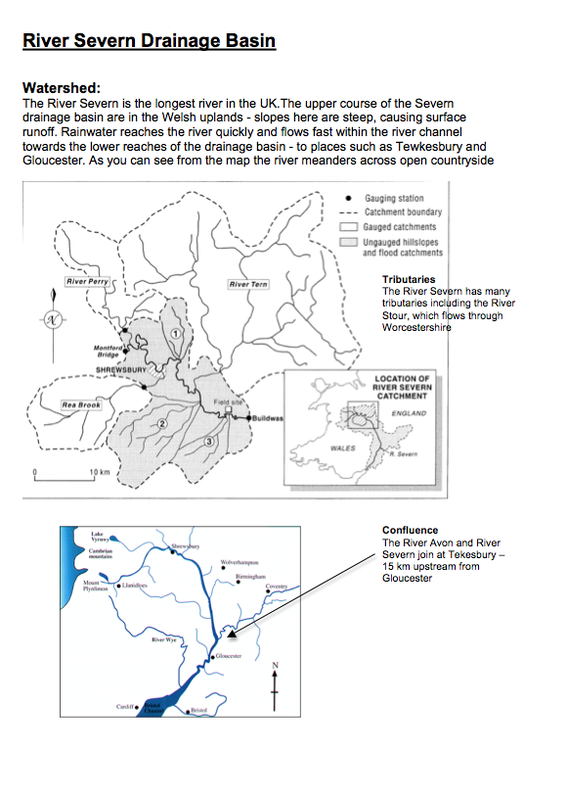
Water enters the drainage basin as precipitation. The drainage basin captures the water and transfers it via surface run-off, throughflow and groundwater flow. The watershed marks the boundary of the drainage basin. The river begins normally in the hills at its source. This could be a marsh, forest or glacier. Larger rivers form from smaller tributaries. When one tributary joins another river it's called a confluence. Finally, when the river joins the sea it's called the mouth. Some river mouths form estuaries. Estuaries are large open areas where the salty sea water mixes with the freshwater of the river.
|
|
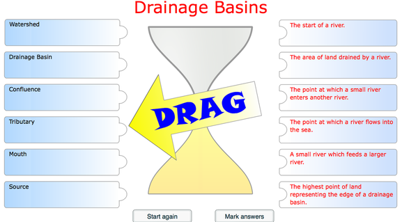
Activity - Have a go at this match up activity
These two videos couldn't be more different. The first is a very creative way of learning vocabulary and the second is to extend your knowledge. It is more detailed but really excellent for helping you understand the processes within a watershed.
|
|
|
River Discharge and Flood Hydrographs
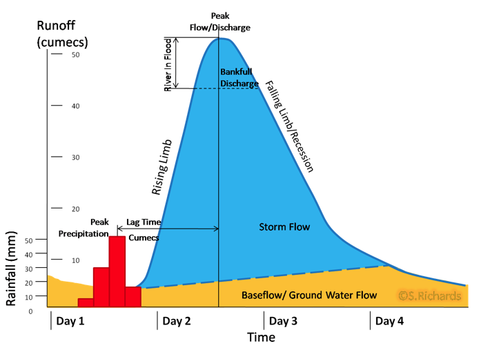
Discharge - The amount of water passing a given point at a given time, measured in cubic meters per second (CUMECS)
Hydrographs show the change in the amount of water passing a given point in a river as a response to a rainfall event. It has some very familiar features that you will need to be able to label. Firstly, there are two Y-axis. One for rainfall and one for discharge. An important label is the peak precipitation. The Discharge has a base flow, which is the amount of water that would normally flow in the river. This increases with rainfall. The steepness of the rising limb shows us how quickly water gets into the river. If it is very steep it's because drainage basin factors have caused this, e.g. steep and impermeable relief. The peak discharge marks the highest point of discharge and the falling limb shows how discharge returns back to base flow. Again the steeper the line the less rainfall reaching the river has moved through the ground. If it was a gentle sloping falling limb then this shows that a lot of water is still reaching the river via throughflow and groundwater flow.
Hydrographs show the change in the amount of water passing a given point in a river as a response to a rainfall event. It has some very familiar features that you will need to be able to label. Firstly, there are two Y-axis. One for rainfall and one for discharge. An important label is the peak precipitation. The Discharge has a base flow, which is the amount of water that would normally flow in the river. This increases with rainfall. The steepness of the rising limb shows us how quickly water gets into the river. If it is very steep it's because drainage basin factors have caused this, e.g. steep and impermeable relief. The peak discharge marks the highest point of discharge and the falling limb shows how discharge returns back to base flow. Again the steeper the line the less rainfall reaching the river has moved through the ground. If it was a gentle sloping falling limb then this shows that a lot of water is still reaching the river via throughflow and groundwater flow.
|
|
|
Hydrograph A
Has a steep rising limb and steep falling limb. It has a short lag time beteen the peak precipitation and peak discharge and high dishcrage levels. This river is very likely to flood more frequently and in this graph it has gone above bankfull. |
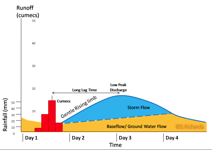
Hydrograph B
Has a much more gentle sloping shape. With the same amount of rainfall it has a much longer lag time, much lower discharge with a very gentle sloping rising limb and falling limb. |
Activity
Try to write the description above as comparison of the two.
Try to write the description above as comparison of the two.
|
Discharge in the river is not really affected by factors immediately alongside the channel. Discharge is either increased or decreased by the characteristics of the drainage basin as a whole.
|
Exam Tip!
Use data in your description. Make direct comparisions and avoid sentences that explain. |
Activity
Have a go at this drag and drop activity to link factors of the drainage basin with the shape of the hydrograph.
Have a go at this drag and drop activity to link factors of the drainage basin with the shape of the hydrograph.

Activity
If you didn't do so well in the test you should use the following resource. It has some good interactive activities and also lots of explanation to explain how the characteristics of the drainage basin influence the shape of the hydrograph.
It is also recommended you use this site to extend your knowledge. You need to explore the site to find this activity.
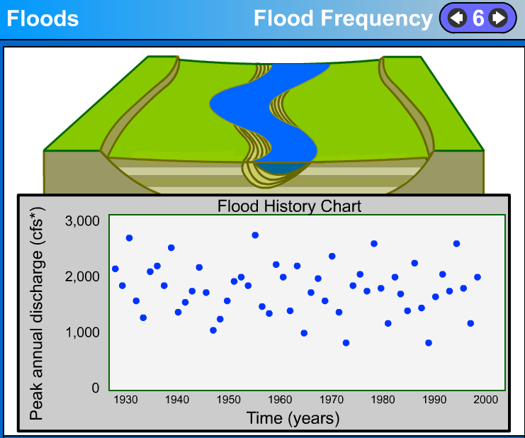
Flood Frequency and River Regimes
Flood Frequency - How often a river floods showing different magnitude
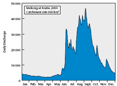
River Regime - How discharge varies in a river over the course of a year.
River Regime - How discharge varies in a river over the course of a year.
The following two diagrams show the recurrence interval of river. As you can see from the dots below the river, the river floods many times at different magnitudes. The larger flood occurs less frequently, with greatest magnitude flood perhaps only occurring once every 100 or 200 years. We call these floods the 100 year flood event. Smaller floods occur more frequently, perhaps more than once every year.
The river regime shows how discharge changes in the year. It is likely to change due to seasonal and climatic changes. e.g. more discharge during the summer months, when rainfall combines with snow melt and least discharge in the winter when it rains precipiation is stored as ice.
The river regime shows how discharge changes in the year. It is likely to change due to seasonal and climatic changes. e.g. more discharge during the summer months, when rainfall combines with snow melt and least discharge in the winter when it rains precipiation is stored as ice.
|
|
River Processes
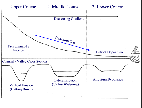
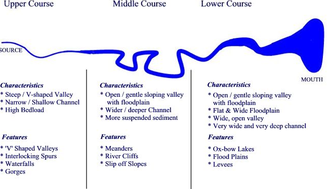
Rivers follow in a distinct pattern of change along their long profile. In the upper course rivers are small, narrow and rocky with steep valley sides called v-shaped valleys. The discharge is low because the volume of water is low and velocity is slow due to friction against big rocks. In the middle course of the river, there is greater volume due to the number of tributaries and the larger area of drainage basin that has fed water into the river. The channel is deeper and wider with floodplains and familiar meanders develop. The discharge and velocity is now faster despite a more shallow gradient because the rocks have been eroded and are now much smaller. Less water is in f iction with bed and banks. In the lower course the river is wider and deeper again, discharge and velocity is greatest. There is likely to be an extensive floodplain, perhaps managed by humans due to agriculture, settlement and industry.
|
|
Activity
Watch the video below, which shows how the River Servern in the UK changes along its long profile. It introduces you to the changing landscape and the processes of erosion transportation and deposition.
Make notes or mind map of all the information.
Watch the video below, which shows how the River Servern in the UK changes along its long profile. It introduces you to the changing landscape and the processes of erosion transportation and deposition.
Make notes or mind map of all the information.
 |
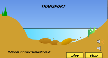
Transportation
Rivers transport load in 4 main ways
1. Traction - large load such as rocks roll along the bed the river. This mainly happens in the upper course
2. Saltation - smaller load such as pebbles bounce along bed and leap frog over each other, again this
occurs in the upper course and perhaps middle course
3. Suspension - Smaller load such as sediment and mud is transported in suspension by the force of the
river. This is mainly in the middle and lower course
4. Solution - some load reacts chemically with water such as limestone. This process forms mineral
water, where the disolved rock is contained in the water

|
|
The following video shows the transportation of material in the river.
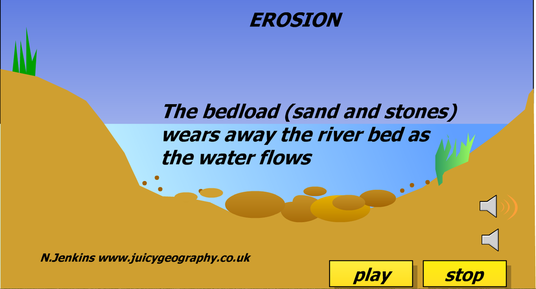
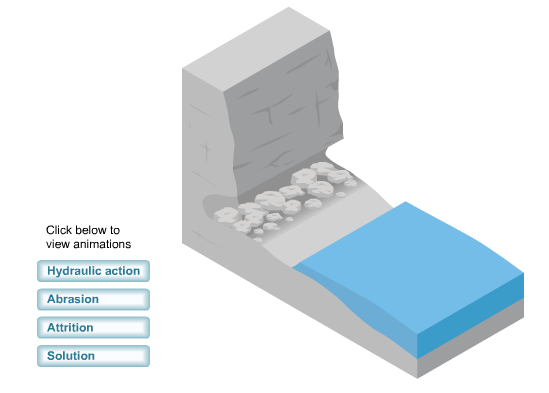
River Erosion
Again like tranportation there are 4 main types of erosion
Abrasion - The scraping of load against the bed and banks
Hydraulic Action - The shear force of the water aginst the bed and banks
Solution - the chemical reaction between some rocks and river water causes the rock to corrode over
time
Attrition - the banging together of load to make it smaller and smoother.
|
Exam Tip!
When defining a type of transportation state where in the course of the irver it mainly occurs. |
|
|
River Landforms
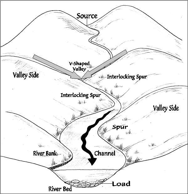
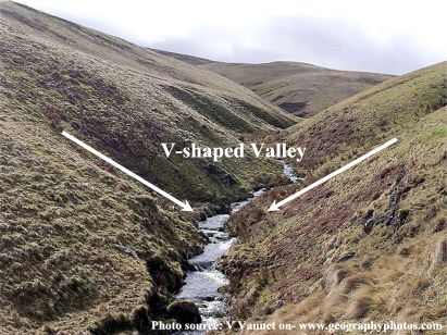
The main river landforms that you need to know for this course ar linked to the sections of the course that they form. In the upper course you should be able to describe and explain the formation of v-shaped valleys, interlocking spurs and waterfalls. In the middle course you should be able describe and explain the formation of floodplains, levees, meanders and ox-bow lakes.
Upper Course Landforms
V-shaped valleys form in the upper course with their familiar interlocking spurs. The main process is vertical erosion. Vertical erosion takes place due to abrasion and hydraulic action due to the potential energy of the river that comes from gravity.
|
|
The following animation explains the processes that form v-shaped valley and interlocking spurs really well. It places the main focus on vertical erosion but also describes the importance of weathering and mass movement processes on the valley sides. These help to reduce the steepness of the slope of the v-shape.
Weathering - the breaking down of rock in situ, e.g. freeze-thaw action
Mass movement - the movement of material down the slope either in one mass or fragmented, e.g. rock
fall
Weathering - the breaking down of rock in situ, e.g. freeze-thaw action
Mass movement - the movement of material down the slope either in one mass or fragmented, e.g. rock
fall
Types of Weathering
Weathering can be split into two main types. physical weathering and chemical weathering. Physical weathering requires a physical force to be acting on the rock, such as the roots of a tree, whilst chemical weathering involves a chemical reaction.
|
Freeze-thaw action
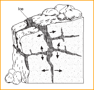
Freeze-thaw action is a type of physical weathering. When water enters cracks and joints in rock it can freeze. It expands and adds pressure to the rock causing small fragments of rock called scree to break off. |
|
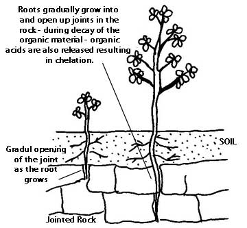
Biological Weathering
Biological weathering is a form of physical weathering. Plant roots grow downwards through cracks and joints in the rock. Over time this increases pressure and causes the rock to break up. |
|
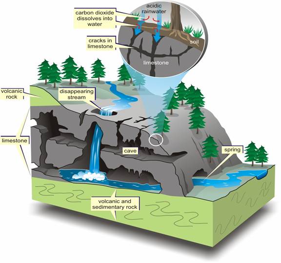
Carbonation
Carbonation is a form of chemical weathering. Carbon dioxide is in solution in rain water. This causes a weak chemical reaction between the carbon dioxide and the calcium carbonate in limestone. Carbonation is responsible for the formation of many features, including sink holes, caves, stalictites and stalicmites |
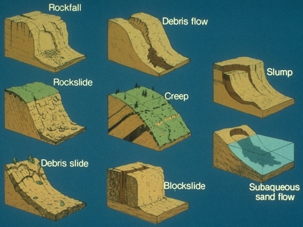
Mass Movements
Mass movements are important to understanding the formation of v-shaped valleys as they help to establish a more gentle graded valley profile. Without weatheirng and mass movements on the valley sides, rivers would cut out much steeper gorge-like valleys. The main type of mass movement results from soil erosion as a result of surface run-off. Other mass movements include the slow migration of soils in the form of soil creep. In more exposed rock valleys, freeze-thaw action hepls create scree fields and rock falls can be common. Finally some clay slopes or unconsolidated slopes can collapse in land slides and slumps.
|
|
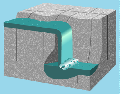
Waterfalls
Waterfalls form from a variety of factors, but the main factor relevant to this course is due to differences in rock resistence. As the river flows over the surface it will erode vertically into the rock. If the river reaches a rock type that is softer compared to the rock further upstream then rates of abrasion and hydraulic action increase and a step or rapid in the river will form. Over time this step increases in size to form a waterfall. As the height increases, so too does the force of the water and it is able to cut out a deep plunge pool as well as an undercut of the hard cap rock. When the undercut becomes large enough it will undermine the hard cap rock above until eventually it collapses. Continued collapse of the hard rock causes the waterfall to retreat upstream, leaving a gorge downstream and hard angular rock in the plunge pool.
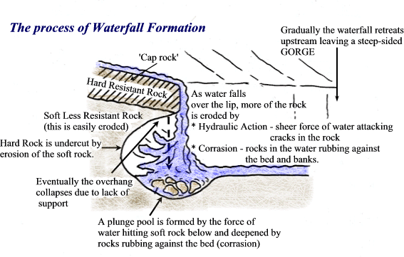
The following animation and video explain the formation of waterfalls.
|
|
