Coastal Environments
Coastal Processes and Landforms
Coastal environments are among the most dynamic and rapidly changing physical environments in the world and with over 2 billion people living within 2km of a coastline these changes are great interest to the geographer.
Coastal Processes
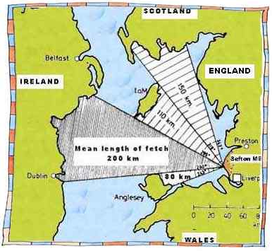
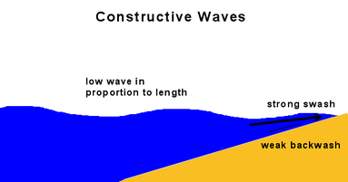
There are many factors that interact to create dynamic coasts. Some coastlines are more vulnerable to erosion than others and some coastlines experience processes of deposition. Coastlines can typically be divided into separate cells where waves interact with land to erode landforms and transport and deposit material. The extent to which one of these three processes becomes dominant depends on three main factors. Firstly, the size of wave influenced by the size of fetch. These can be either constructive waves or destructive waves. Secondly, the shape and orientation of the coastline relative to the direction of prevailing wind and thirdly the type and structure of rock.
Glossary
Erosion - the breaking down of rock by an agent of erosion,
e.g. waves
Transportation - the movement of material within a cell,
e.g. along a beach
Deposition - the dropping of material due to a fall in energy with resulting depsotional landforms
e.g. beach or bar
Fetch - The lenghth of time and distance that wind has acted on the water. Large fetch creates large
waves.
Constructive waves - Low spilling waves with long wave length relative to wave height. Asccoiated with
shallow gradient beaches
Destructive waves - High plunging waves with short wave length relative to wave height. Associated with
steep gradient beaches
Prevailing wind - The dominant wind direction and therefore wave direction
Shape and Orientation - The direction a coast faces relative to the oncoming waves and prevailing wind.
Type and strcuture of rock - Rocks can be hard or soft e.g. granite and clay. Rocks can also have many
cracks which makes them more vulnerable to erosion.
Waves and Fetch
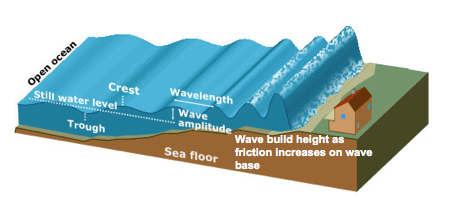
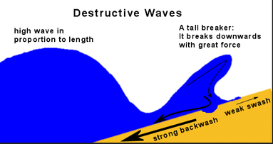
Fetch is the length of time and distance that wind has acted on the water. The longer the distance of ocean and the dominance of one prevailing wind the greater the length of fetch. Waves are formed in open ocean by the stabbing nature of wind on water. The longer this process goes on the bigger the waves become. . Large fetch results in large destructive waves and erosional landforms. Small fetch results in small constructive waves and depositional landforms. Waves also increase in size as they approach the shorezone due to shallower water. Friction increases on the wave base and slows it down. This builds wave height as the wave crest takes over the wave base.
|
|
|
|
|
Main Features of Constructive Waves
|
Main Features of Destructive Waves
|
Activity
Watch the two video below and try and identify the characteristics of the two types of wave.
The third video provides a general overview
Watch the two video below and try and identify the characteristics of the two types of wave.
The third video provides a general overview
|
|
|
Rock and Shape of Coasts
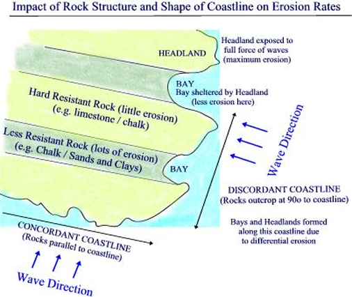
An important factor to consider is the type of rock and its resistence. Hard rock is eroded much slower than soft rocks. The way the cliff is aligned to prvailing wind is also imprortant. If the cliff line is discordant then different rock types are aligned at 90 to the oncoming wave. Discordant coastlines produce headlands and bays. If a coastline is concordant then one type of rock faces the oncoming wave. The rock is parallel to the oncoming wave and less landforms of erosion form. Deposition is more dominant on concordant coasts. Headland and bays can also form where the rock is heavily jointed. Cracks in the rock are more vulnerable to erosion.
Cliff Processes
|
Glossary
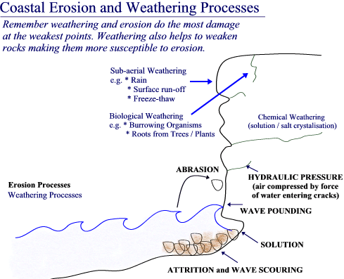
There are four types of erosion at coasts. Abrasion - The scraping of rock and sand against the cliff Hydraulic Pressure - The forcing of air inside cracks by the force of the wave Solution - The chemical reaction of some rock types with water Attrition - the erosion of rocks by them knocking together There are also a number of important weatheirng processes Freeze- thaw action - Water freezes in cracks and pressurises the crack Biological weatheirng - roots of plants and burrowing animals make cracks bigger Salt Chrystalization - waves deposit salt in cracks that over time foce cracks open. |
|
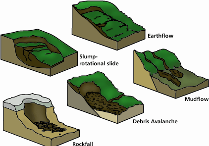
Mass movements are also at work on cliffs
Surface run-off and soil ersosion - Rainfall washes soils and clays away looseing larger rocks
Rotattional slumps - Water saturates slopes and collects within the cliff above an impermeable layer. This creates a slip plane for a slump
Rockfalls - Loose material formed by surface run-off and other weathering processes causes rocks to fall.
Activity
Attempt to investigate in the photograph the factors that might have caused the slump at Scarborough
|
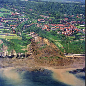
Holbeck Hall, Scarborough
|
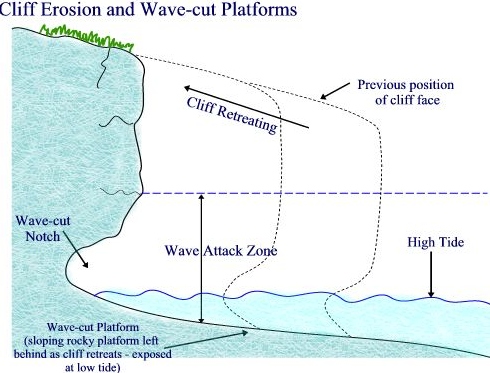
The Formation of Cliffs and Wave-cut Notches
Cliffs and their associated features are formed over long time frames by the repetitive process of erosion at the base of the cliff between high and low tide.
At first land would have met the sea as a gentle sloping face. Over time the waves through the process of abrasion and hydraulic pressure erode the base of the slope to form a wave-cut notch. This notch slowly undercuts the slope untill a section collapses to form a steep step (the beginning of a cliff). This process repeats itself over time with the notch increasing in size and larger sections of cliff collapsing. The final resulting landform is a high cliff face and large flat bedrock wave-cut platform. This platform is solid bedrock and part of the same section of rock that the cliff.
At first land would have met the sea as a gentle sloping face. Over time the waves through the process of abrasion and hydraulic pressure erode the base of the slope to form a wave-cut notch. This notch slowly undercuts the slope untill a section collapses to form a steep step (the beginning of a cliff). This process repeats itself over time with the notch increasing in size and larger sections of cliff collapsing. The final resulting landform is a high cliff face and large flat bedrock wave-cut platform. This platform is solid bedrock and part of the same section of rock that the cliff.
|
|
Exam Tip!
When drawing a diagram of how these features form include numbers and link to the numbers in your sequenced explanation.
When drawing a diagram of how these features form include numbers and link to the numbers in your sequenced explanation.
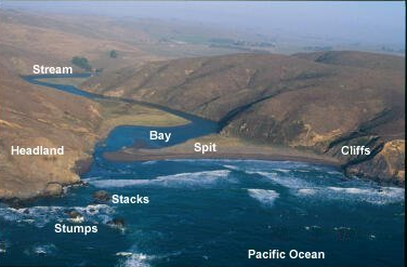
Headlands and Bays
Headlands and bays form mainly along discordant coastlines where different types of rock face the oncoming waves at 90 degrees. Softer rocks are eroded much faster than harder rocks and so bays form. Hard rock outcrops form headlands. Over time headlands attract high energy destructive waves through wave refraction and the bays create sheltered low energy zones where constructive waves deposit material to form beaches.

|
|
Wave refraction and the distribution of destructive and constructive waves around headlands is well explained in the following video podcast.
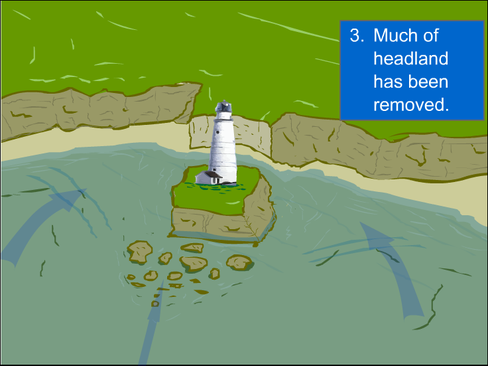
Features of Headlands
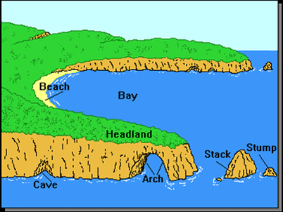
Due to wave refraction and the energy of destructive waves being focused on the sides of headland many features of erosion form on the flanks of headlands. These include, cracks, wave-cut notches, caves, arches, blow holes, stacks and stumps. Wave refraction wraps waves and centres the energy around the headland. Due to a wave-cut platform of the headland, wave height builds quickly and destructive waves form and erode the sides of the headland. At first hydraulic pressure expands cracks to form small notches that late develop into caves. If two caves on opposite sides of the headland deepen and meet an arch forms. Vertical joints within the arch roof may become exposed by abrasion and hydraulic pressure resulting in blow holes and chimney features. These joints are also weathered from above and eventually collapse under gravitational force. The resulting feature is a stack, which undergoes erosion. Notches develop at the base of the stack and weathering process break down the rock from above. When the stack collapses a stump forms. Follow the process in detail in the following reosurce. Click on the image and then overview.
Activity
The video is one of the original plastercine time-lapse videos put on youtube and remains one of the best. How many erosion features can you spot.
Activity
The video is one of the original plastercine time-lapse videos put on youtube and remains one of the best. How many erosion features can you spot.
|
|
Landforms of Deposition
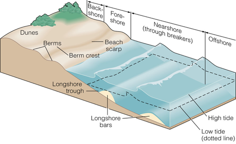
The most important landform of deposition but ironically the one that students often forget is the beach. Beaches form at the forshore through the transportation and deposition of material. Large beaches form at coastlines where there is a constant supply of sediment, generally under constructive waves. Constructive waves have dominant swash and transport material up the beach. Coastlines that have dominant destructive wave patterns tend to have narrower and steeper beaches because of the stronger backwash. Various other features form on beach profiles, including off-shore bars, berms and dunes
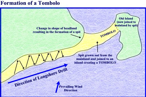
Longshore Drift and Associated Landforms
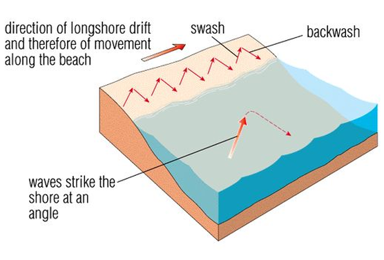
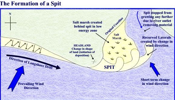
Longshore drift is the movement of material along the beach due to the direction of prevailing wind. If the coastline is drift aligned then prevailing wind blows waves in at an angle to the coastline. As the wave breaks, material is transported by the swash in the direction of the wave, but gravity returns the backwash perpindicular to the coast. In this way material is transported down the coastline in a zig-zag pattern. Over time material will build up at the far end of the coast. If the coastline changes direction or a low energy zone develops, perhaps due to an estuary then a spit or a offshore bar may form.
|
|
Activity
Try numbering the diagram above to show the order of sequence to explain the formation of spits. |
Exam Tip!
Describing and explaining the formation of a spit is a common exam question. Remember to always start the sequence with prevailing and refer to swash and back wash. When describing the spit, make sure you make clear reference to its features, e.g. recurved laterals or hooks, slat march with lagoons and salt resistent plants
Describing and explaining the formation of a spit is a common exam question. Remember to always start the sequence with prevailing and refer to swash and back wash. When describing the spit, make sure you make clear reference to its features, e.g. recurved laterals or hooks, slat march with lagoons and salt resistent plants
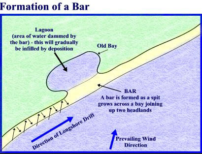
Other depositional features resulting from longshore drift include tombolos and bars. Tombolos are bars that link the mainline coast with an island. Bars are extensions of beach which are deposited into the sea where there is a change in the direction of coastline. Lagoons often form behind bars.
|
|
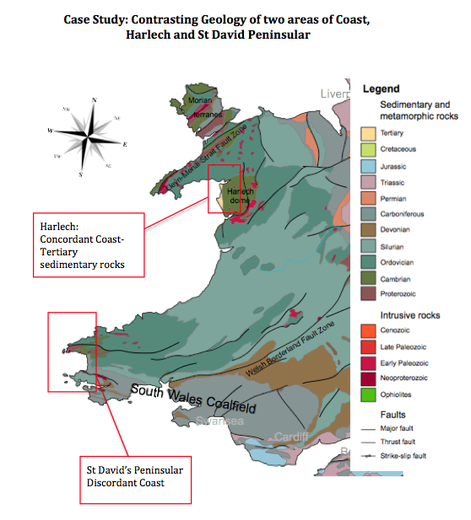
Case Study: Two Geologically Contrasting Areas of Coastline: St David's Peninsular and Harlech
This case study requires you to contrast two geologically different coastlines. The best way to do this is through contrasting concordant with discordant coasts as this allows you to develop both the geological differences and the different coastal features and processes. Concordant coastlines are generally associated with deposition and discordant coastlines and generally associated with erosion. The following image links to a PDF case study file and the videos referred to can be found on this page.
Sea Level Change and Landforms
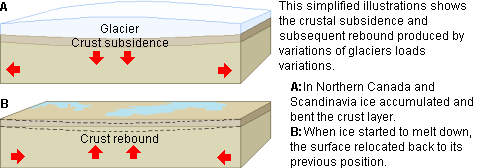
Sea level rise has been very slow in recent years but quite rapid if we go back 10000 or 20000 years. At this latter time frame the world was experiencing an icea ge and as the world came out of that ice age about 11000 years ago the world experienced rapid sea level rise as ice sheets melted and water beaceme stored in the ocean. This type of sea level rise is called eustatic rise. A second cause of sea level change is do with changes in the poistion of land. This is called isostatic change. Is isostatic change is caused when the land sinks into the mantle causing sea level rise. Isostatic rise is caused when land rises back up causing a fall in relative sea level. Ice sheets during the last ice age could be several kilometers in thickness in places and this great weight pushed the land down into the mantle. Once the ice melted the land rebounds back. Istostic rise is present in places of Canada and closer to home in western Scotland. The two vodeos below show the process of eustatic and isostatic rise.
|
|
|
|
|
This video is very old but does include a section at 2 minutes on Hudson Bay on isostatic rise.
|
Isostatic Change
Isostatic rise due to the melting of ice sheets allows the crust to rise. This poduces local coastal features such as relic cliffs and terraces, relec beaches and relic wave-cut platforms.
|
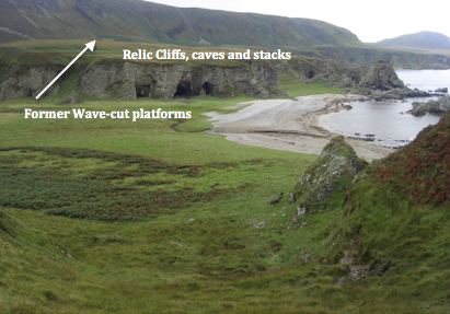
Islay Island West Scotland
|
Eustatic Change
Eustatic rises in sea level have occurred at the global scale for the last 20000 years or so. Eustatic rise forms some beautiful coastal landscapes. In post glacial environments like Norway, fjords and fjards develop where deep valley and open coastal plains flood. In some low lying river valleys rias form as the sea encroaches. The resource by Miss B provides an excellent overview.
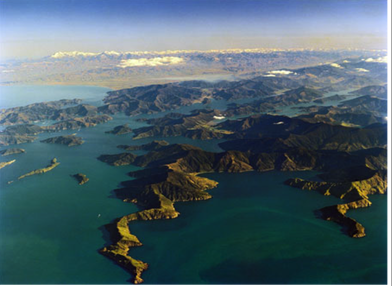
Drowned Valleys, fjords, fjards and skerries
|
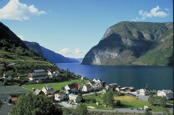
Norwgian Fjord
|
