Hazardous Environments
Some places are more hazardous than others. This course explores both tectonic and climatic hazards, incluidng their causes, distribution and impacts.
A natural hazard can be defined as threat of a naturally occurring event that will have a negative effect on people or the environment. There are different types of natural hazard but for the purpose of this course we will concentrate on only climatic and tectonic.
Activity
Try classifying the following hazards into climatic and tectonic.
The Distribution of Tectonic Hazards
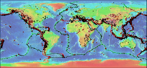 http://ees.as.uky.edu
The interactive map to the left shows the location (distribution) of both earthquakes and active volconoes. As you can see they appear to follow a distinct pattern. This pattern relates strongly with the location of plate boundaries and their associated tectonic processes. It's important to describe this pattern in depth.
Exam Tip
When describing patterns from maps remember to use different scales. Here is a step by step guide:
1. Start with the global scale and general pattern, e.g. both volcanoes and earthquakes occur along the plate boundaries.
2. Quantify your description whenever possible
3. Refer to specific regions or continents. e.g. Most volcanoes occur around the Pacific Ring of Fire
4. Use specific vocabulary where possible, e.g. Earthquakes occur at all plate boundaries but are the only hazard to be found at conservative plate boundaries.
5. Refer to anomolies, e.g. Some volcanoes are found away from plate boundaries at the location of mantle plumes, e.g. Hawaii.
6. For a question that askes to describe a pattern you must avoid explanation.
Types of Plate Boundary
There are four main types of plate boundary
1. Conservative Plate Boundaries or transform faults - here two plates slide alongside each other and create shear stress associated with earthquakes.
2. Constructive Plate Boundaries or divergent - here two plates move away from each other and form new ocean crust.
3. Destructive Plate Boundaries or convergent - here two plates collide with the more dense oceanic crust subducted under the less dense continental crust.
4. Collision Boundaries - here two continental crusts collide and due to equal mass and density large fold mountains develop.
The following two videos provide an excellent insight into plate boundaries and the processes that occur at them.
|
|
|
Earth's Structure
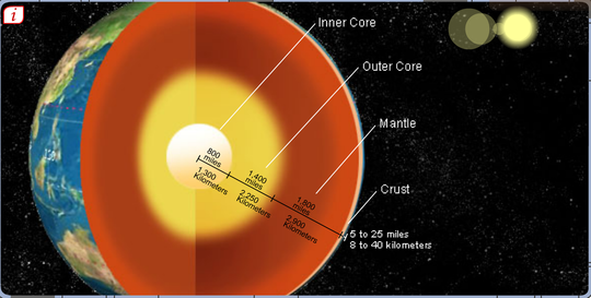 http://www.myscience8.com
To undertstand how plate boundaries form and explain the occurence of earthquakes and volcanoes it is important for you to understand the structure of the planet. The interactive diagram to the left shows the structure of the planet, which can be simplified and divided into 4 sections:
- The crust
- Mantle
- Outer core
- Inner core
In terms of size the crust is thought to be the equivalent of the skin of an apple. It varies from just 8km to to 40km in thickness and is divided into oceaninc crust and continental crust. Oceanic crust is younger and denser, whist continental crust is older, less dense and much lighter. The mantle is approximately 2900km in depth and the largest section of the earth.
|
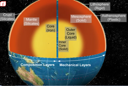
In the diagram you can see that the mantle is further divided into the mesophere and the asthenosphere. The mesosphere is solid rock and the asthensophere is plastic. Solid and plastic refer to the mechanical properties of the rock. When subjected to stress, solid rock shows very little deformation and plastic rock shows continuous deformation. It can be likened to plastercine. The mantle is mainly made of silicates and varies from 3000°C in the lower mantle to 1400°C in the upper mantle. The core shows significant variation in it mechanical properties but is largely made of iron and nichol minerals. The outer core is liquid due to its high temperature, which varies between 1000°C and 2000°C. The inner core is solid despite its immense temperature, varying from 8000°C to 10000°C. It remains solid because of the intense levels of pressure which changing the melting point of its composition.
|
|
Continental Drift
The following two videos explain the source of heat in the earth's core. They refer to the radio-active decay of material and explain how this generates heat that is then transferred through convection cells within the mantle. These convection cells drive the movement of the earth's crust through frictional forces creating plate movement. This plate movement is referred to by geographers as continental drift.
|
|
|
Plate Boundaries and Associated Landforms and Processes
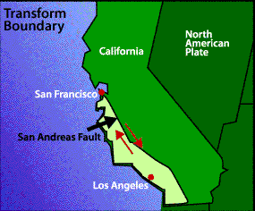
Conservative Plate Boundaries
|
Conservative plate boundaries or transform faults like that found at San Andreas Fault in California result from the movement of plates alongside each other. As they move shear stress results from friction along the boundary. When stress is released earthquakes occur. The San Andreas fault is associated with high frequency low magnitude earthquakes but sometimes high magnitude earthquakes occur like the 1906 San Francisco quake, which killed 3000 people. Further Reading on San Andreas earthquakes.
|
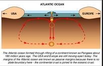
Constructive Plate Boundaries
|
Constructive Plate Boundaries form mid-oceanic ridges. At these boundaries two oceanic plates move apart. At the point they separate new ocean floor is formed. An example is the Mid Atlantic Ridge and as a result the continents of North America and Europe are moving further apart. Some constructive margins form over continents and these are called Continental Rift Valleys. An example is the Great Rift Valley in East Africa.
|
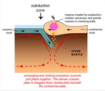
Destructive Plate Boundaries
|
The most common form of destructive plate boundary occurs when the dense oceanic crust is subducted under the lighter continental crust. This is marked by a deep oceanic trench. An example can be found on the West coast of South America as the Nazca Plate is subducted. As the plate is subducted it is broken down and magma forms. In addition large quantities of water are subducted and change the density of the mantle causing magma to rise through fractures in the crust. Eventually large volcanoes chains form.
|
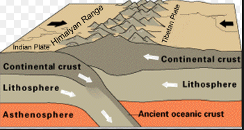
Collision Boundary
|
Collision Boundaries often refer to the development of large fold mountains when two continental plates collide. A good example is that of the collision between India and Eurasia, thought to have taken place 40 million years ago. As two continental plates of equal density collide they buckle up and fold. In this way the Himalayas and Mount Everest were formed. The same process is going on today between the African Plate and Eurasian Plate.
|
ACTIVITY
Create your own thinklink like the partly completed one below. Use your own images, text and videos to describe the processes at work at each plate boundary.
Create your own thinklink like the partly completed one below. Use your own images, text and videos to describe the processes at work at each plate boundary.

Earthquakes
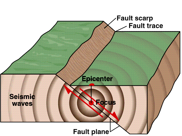
Earthquakes refer to the sudden movement of the surface due to a release of energy in the form of sesimic waves. They are primarily caused by a release of stress within a fault. As this stress is released shock waves of energy travel through the crust away from the focus of an earthquake. there are three types of seismic wave
Primary Waves - These are the fastes moving and travel in the direction of movement
Secondary Waves - These are slower than primary waves and move across the line of direction of movement
Surface Waves - These are the most dangerous and travel on the surface both across the line and along the line of direction of movement
|
|
Volcanoes
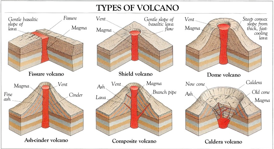
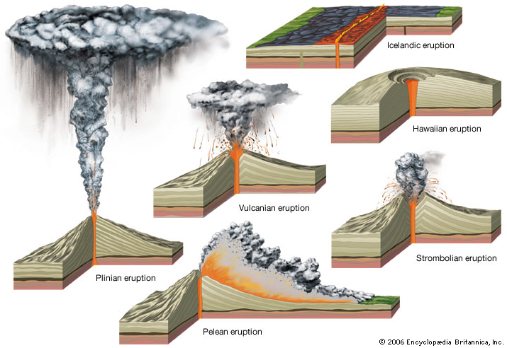
There are different types of volcano and different types of eruption depending on the location of the volcano and the type of plate boundary it sits on. The type of eruption is closely linked with the type of volcano. Powerful destructive eruptons helps build high volcanoes. Mild more gentle eruption produce flatter volcanoes that extend over a large surface area.
|
|
ACTIVITY
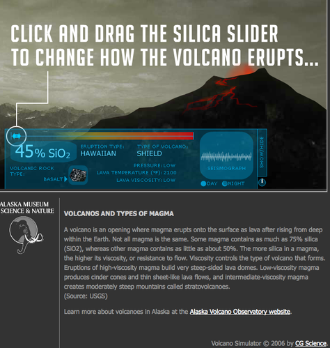
Use the volcano simulator below to investigate the factors that create explosive volcanoes.
Use the volcano simulator below to investigate the factors that create explosive volcanoes.
Primary and Secondary Hazards
Both earthquakes and volcanic eruptions bring multiple hazards. Primary hazards are those associated with the immediate event. For example material ejected from the volcano, shaking ground and collapsing buildings. Primary hazards can be dangerous and their impacts severe but you should also be aware of the secondary hazards. Secondary hazards occur indirectly as a result of the primary hazard and can be equally if not more dangerous than the primary hazards.
ACTIVITY
Have a go at the dustbin game to classify primary and secondary hazards for volcanoes and earthquakes
ACTIVITY
Have a go at the dustbin game to classify primary and secondary hazards for volcanoes and earthquakes
The following video uses original footage of the hazards linked to the 1980 Mount St Helens Eruption in Portland USA. Watch it to identify the primary and secondary hazards.
Tropical Revolving Storms
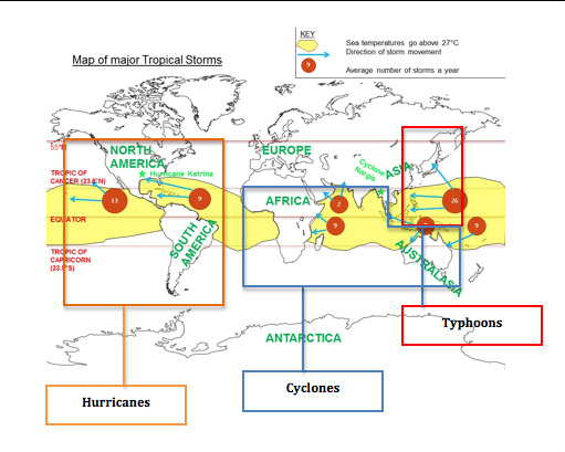
The map to the left shows the distribution and frequency of tropical revolving storms. Again their is an important skill here in describing its pattern.
1. General global pattern
2. Develop data if possible
3. Identify more regional patterns and variations
4. Are there any anomolies
ACTIVITY
Complete the following paragraph
Tropical revolving storms occur mainly in ______________oceans with a temperature of 27.5°C. They tend to occur more in the __________________ hemisphere. East Asia and mainly Japan tends to have the highest frequency of storms called ______________ with an average of _________ a year. The west coast of Africa, Australia and South Asia also get tropical storms called _______________, Finally North America in both the Atlantic and Pacific have on avergae __________ hurricanes a year.
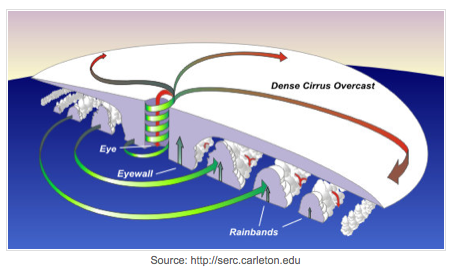
The Causes and Characteristics of Tropical Revolving Storms
|
|
Tropical Revolving Storms develop as disturbances along the Tropical Jet Stream. These disturbances are called easterly waves and as they move they begin to create clusters of tropical depressions. As they travel over warm tropical waters of 27.5°C with depths of 100 meters they begin to get more organised. They draw in moisture and heat from the warm oceans and winds are drawn into them from above. As they strengthen they develop a central eye and on their flanks a series of well structured towering cumulonimbus clouds. Winds speeds are in excess of 119 km for category 1 storms but 252 km per hours for category 5 storms. The systems create spectacular electric storms and accompanied by torrential rainfall and a tidal surge, often several meters high near coastal areas. For more indepth reading see The British Geographer.
|
Primary and Secondary Hazards Associated with Tropical Revolving Storms
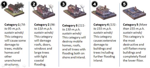
The main primary hazard associated with tropical revolving storms is strong wind and the debris that those winds carry with them. Hurricane force winds have been known to move cars. An accompanying hazard is a tidal surge, which can reach heights of several meters. These tidal surges bring behind them a vast quatity of water. Many properties and people are vulnerable to flooding. Secondary hazards can be flooding linked to breached coastal defenses and injury and death from fallen trees. The main scale for measuring the scale of tropical revolving storms and the hazards they bring is the Saffir-Simpson Scale. This rates tropical revolving storms on a 5 point scale. The interactive BBC resource below runs through the causes of hurricanes as well as the impacts associated with the Saffir Simpson Scale.
|
|
The Measurement of Weather Systems
Today the vast majority of weather systems can be identified and tracked using satellite imagery, heat sensory equipment and sophisticated computer modelling. This technology enables meteorologists to predict the development of tropical revolving storms, track their development and predict their track. In addition to satellites, meteorologists use weather stations from ships and weather balloons to accurately measure air temperatures, pressure gradients and wind speed. Traditional weather instruments include the anemometer for measuring wind speed, the barometer for measuring air pressure and the thermometer with Stephenson Screen for measuring air temperature. For more detail see the fieldwork section of this site
